Wednesday, January 24, 2018

Corona Arch

Corona Arch was the main attraction on our agenda for December 3.  It's a mile and a half each way.  The first point of interest was crossing this train track carved into the mountain:


Ed heads up the trail.  The light conditions are actually going to improve but we don't know that yet, so I'll show you just a couple of pics of the hike there, and we'll see more landscape from the way back later on.


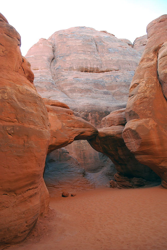
We're here!  This isn't it though, this is Bowtie Arch, a pothole arch right beside Corona Arch.  It was formed when a pothole of water eroded into a cave below:


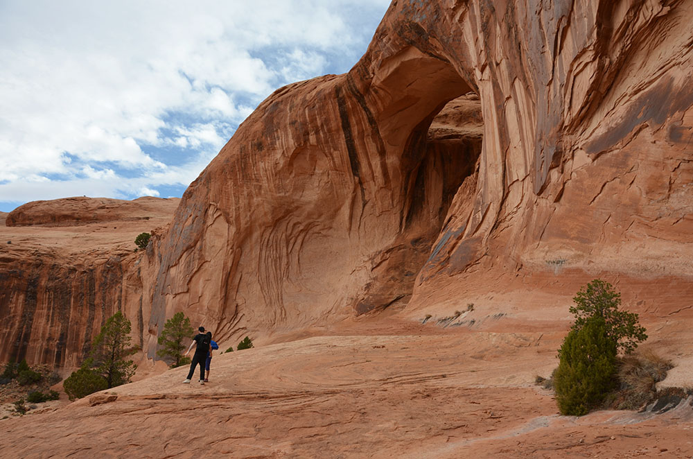
Here's Corona.  It's more elephant-trunk like to me, but whatever:


While we were there we had a nice surprise, a potash train chugged into view and made its way through the canyon:


Corona Arch from the other side:


These eroded holes on the far side of Corona Arch are said to look like Jabba the Hutt.  As the sole remaining North American who has not seen Star Wars, I couldn't tell you:


Another look at Bowtie Arch as we start moseying back.  Those guys in the foreground were doing some sort of rapping music video:


The light conditions are starting to improve, but we don't have time to hang around and wait, but here's another look at Corona as we head back:


Corona arch is in the one below too, you can hardly see it but it's towards the centre left:


Ed on the trail as the landscape lights up:


We were done the hike sooner than we expected, so we headed back down the road to try another trailhead we had stumbled upon earlier in the day.

Tuesday, January 23, 2018

Potash Rd. Scenic Drive

On Dec. 3 we took a break from Arches Park (we're not done there yet) and took a drive down Potash Rd. to see a few arches that live down that way.

The day was overcast, so the photos aren't that stunning, but these cliffs that hug the road are pretty impressive.  When they put the road in, they cleared away the talus at the bottom of the cliffs, which is partly why they are so relentlessly vertical down to the base.  The cars parked belong to climbers:


There are petroglyphs on the cliffs along the road:


This train was parked near the potash plant:


The Colorado river, which also hugs the road:


A couple of photos of the potash plant:


This is Jug Handle arch, we stopped for a photo of it as we drove back:


Next stop is our hike to Corona Arch.

Monday, January 22, 2018

Arches National Park: Sand Dune Arch and Broken Arch

After Delicate Arch, we headed north on the main road to see the sights and take in a couple more arches.

Our first stop was at the Fiery Furnace viewpoint.  We're going to go down and hike in there in a few days:


Looking south from the viewpoint:


Driving further up the road, we start coming to the fin formations in the sandstone:


We stopped around 10 times to take photos, but I'll restrain myself and just give you a taste:


We parked and started hiking towards Sand Dune Arch.  It's located in the fins, but we don't know that yet:


Here the trail turns into the fins:


Before very far you come into an open area, and there's the arch:


It looks so peaceful in here, and it is, except that while we were there there was a group of 3 families taking a break and hanging out, with around 10 kids under 10 screaming and chasing and shooting everywhere like electrons, and one of the Dads was (illegally) walking on top of the arch.  I had to just stay still and wait for all the kids to briefly fire themselves out of my viewfinder and then snap:


We turned back out of the fins and headed down the trail towards Broken Arch.  More fins and towers along the way:


Here we are.  It's not actually broken, but calling it that might help to keep the crowds away, we didn't see any other hikers on this part of the trail.


Broken Arch from the back, with Ed focusing on something else interesting off to the left:


There was another arch further down the trail, but we turned around here.  It was getting late in the day, plus it was a little hard to tell if the trail was fully open or not, as part of it was closed due to the road repairs they had been working on.

Sunday, January 21, 2018

Arches National Park: Delicate Arch

Delicate Arch is supposedly the most famous arch in the world, and it's the iconic arch that is on the Utah license plates.  So Dec. 2, that's where we went.

Here's what the landscape looks like as we drive down the access road:


At the start of the hike, the trail goes past a historical site.  Wolfe Ranch is were some folks from Ohio settled for a few years from the late 1800's, until they returned to Ohio in 1910.  This is the second, more luxurious cabin they built (all one room of it):


Their old corral, with the modern version of a corral, the parking lot, visible at the upper left:


This was their original digs, literally, a dugout.  They lived here for many years until an adult daughter and her family came to live with them in 1906 and convinced her father to build the 1-room cabin:


Just past the cabin, we crossed over this little stream:


Landscape southeast of the trail:


View to the north-ish:


A big part of the trail is this huge slickrock "ramp" that you hike up.  This photo doesn't do it justice as to how massive it feels:


Looking back towards where we started out:


Once past the ramp, the trail starts meandering a bit into eroded stone formations:


In places there are dead trees laid to loosely indicate the direction to go in, and not to wander off the trail past the logs:


Some more slickrock:


On the final stretch we were hiking on a fairly narrow carved-out ledge, hugging the side of the mountain:


This is the view opposite that stone ledge, it was quite breathtaking:


Then suddenly, you round a corner, and there it is!  The sun was behind it so not the greatest for photos, but pretty awesome all the same, this arch on top of a mountain:


Some more formations that surround the hollow in the mountain that hosts the arch:


Ed at the summit:


After hiking back down, this interesting pocked rock caught my eye:


There are some petroglyphs near Wolfe Ranch, we took the little detour to see those on the way back.  These have horses in them so they're dated as being from around 1650-1850.


One more view of that little body of water, it looks so soothing in a desert environment:


So that was Delicate Arch.  It is a relatively busy trail (and early December is the low season), but very worthwhile.