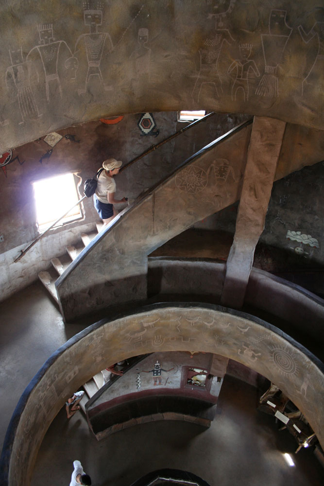
On the third day, I went out to the Desert View area, where there's a watchtower and good views of the eastern portion of the canyon. The watchtower was built in the 1930's, it has a gift shop on the main floor, a viewing area at the top, and a deck part-way up for viewing as well.
Don't worry, I won't torment you with a million views, just a couple. You can see the flat desert beyond the rim in the photo below:
You can see the Colorado river in these two:
OK, so I won't torment you with more canyon photos but it was a pretty cool building, so I have some photos of it. The outdoor viewing deck:
The viewing area at the top of the tower:
Stairs, and circular landings every storey's worth of stairs:
Looking up at a decorated ceiling:
Mural:
Next stop: the Tusayan ruins, a Pueblo Indian archeological site.
Friday, October 22, 2010
Wednesday, October 20, 2010
Big Horn Sheep
On the way back up the Bright Angel trail, I could see traffic building up ahead, becoming stop and go. Here's why:
This big-horn sheep (with smallish horns- young?) wasn't too intimidated by the hikers, and scampered up rocks to graze and pose for us:
It may have been the mother of these younger and more skittish sheep that were running up and down on the rocks below. There were other sheep lurking off in the woods above the trail.
All right, I still have more photos to show you. The light and shadows kept changing which is partly why I have so many:
Now tell me, does this trail look steep or narrow to you?
If you remember to look up, there are always scenic outcrops to see too:
More trail:
There were a few flowers in the canyon, I found these photogenic:
A couple more rocky outcrops:
And, one last shot from this trail. I still have more photos to come from my third day at the canyon, so don't slip into that coma just yet...
Monday, October 18, 2010
Bright Angel trail, part 2
I hope I'm not putting you to sleep with all these photos. The landscape was just so stunning though.
Here's the trail, getting down into a reddish layer of rock now:
Love the shadow patterns!
The trail is headed to a second tunnel that you can see in these next photos. In the first one, you can also see the trail snaking away below it.
More irresistible cloud shadows:
The skies were also very interesting that day:
Here's a mule-trip group heading up:
See, I really was there!
You can see the switchbacking of the trail in the lower part of the photo below:
I like this one, it has an "inside the canyon" feel instead of looking down like most of the rest:
This is the weathered rock on one part of the canyon wall, I think they get high winds and some extreme weather in some seasons:
In my next post... big horn sheep, up close! I should have those photos up in a couple of days, so don't go far...
Here's the trail, getting down into a reddish layer of rock now:
Love the shadow patterns!
The trail is headed to a second tunnel that you can see in these next photos. In the first one, you can also see the trail snaking away below it.
More irresistible cloud shadows:
The skies were also very interesting that day:
Here's a mule-trip group heading up:
See, I really was there!
You can see the switchbacking of the trail in the lower part of the photo below:
I like this one, it has an "inside the canyon" feel instead of looking down like most of the rest:
This is the weathered rock on one part of the canyon wall, I think they get high winds and some extreme weather in some seasons:
In my next post... big horn sheep, up close! I should have those photos up in a couple of days, so don't go far...
Friday, October 15, 2010
Bright Angel trail, part 1
There are many signs at the Grand Canyon warning people about the dangers of hiking into the canyon. Basically, they say "take all precautions, and maybe don't go at all, or you could die! die! die!" At the trailhead to the Bright Angel trail, which is right in the village (so accessible to anyone with a sudden whim to go for a hike) there is a panel telling the tragic story of a woman who was fitter than most of us, who could run the Boston Marathon, but who died hiking the Bright Angel trail.
I have to say though, if I would have known how easy a hike this would be, I would have hiked more of it. I hiked the first portion down into the canyon, to 1 1/2 mile house (where there are restrooms and water), and that was around a 1200 foot drop in elevation. This trail also shaded in many areas, which makes it easier, although the day I hiked it it was not that hot.
I found the trail to be wide and not steep, although everywhere in the literature it is touted as being narrow and very steep! It's relentlessly up/down (depending which direction you are headed) with constant change in elevation, so maybe they interpret that as "steep", but at least on the portions that are within reach of the average muggle hiker, it is not a steep trail. Very gradual slope, lots of switchbacks.
I guess they post so many warnings because so many average folks with little hiking experience could be skipping easily down the trail and not realizing that it will take more energy once they turn around to come back. Still, I found that it took me about the same amount of time coming up as going down. Guess I must be reasonably fit. It's definitely an easier hike by far than climbing the hills and mountains around Arctic Bay.
So here are a few photos from the hike- I'll post more soon.
This first one is at the top of the trail- looks like they are repositioning some mules that take tourists into the canyon. Seems like such a waste to bring these guys back empty though- I would love to hike into the canyon and then hitch a ride on a mule back.
Here's a bend early on in the trail, where it takes the hikers through a short tunnel cut into a piece of the canyon that juts out:
It was sun and cloud that day, made for beautiful shadow patterns in the canyon, always changing:
Here's that tunnel:
Just on the other side of the tunnel:
The canyon wall, a bit below the rim:
The shadows changed from minute to minute, my favourite picture-taking conditions. I couldn't resist taking way too many pictures again:
Looking back up at the canyon wall again. As you can see, there's vegetation and trees down in the canyon:
This is the trail itself- as you can see, wide, well-maintained, easy to follow:
I still have more photos to go through, so I will post more from this trail soon.
I have to say though, if I would have known how easy a hike this would be, I would have hiked more of it. I hiked the first portion down into the canyon, to 1 1/2 mile house (where there are restrooms and water), and that was around a 1200 foot drop in elevation. This trail also shaded in many areas, which makes it easier, although the day I hiked it it was not that hot.
I found the trail to be wide and not steep, although everywhere in the literature it is touted as being narrow and very steep! It's relentlessly up/down (depending which direction you are headed) with constant change in elevation, so maybe they interpret that as "steep", but at least on the portions that are within reach of the average muggle hiker, it is not a steep trail. Very gradual slope, lots of switchbacks.
I guess they post so many warnings because so many average folks with little hiking experience could be skipping easily down the trail and not realizing that it will take more energy once they turn around to come back. Still, I found that it took me about the same amount of time coming up as going down. Guess I must be reasonably fit. It's definitely an easier hike by far than climbing the hills and mountains around Arctic Bay.
So here are a few photos from the hike- I'll post more soon.
This first one is at the top of the trail- looks like they are repositioning some mules that take tourists into the canyon. Seems like such a waste to bring these guys back empty though- I would love to hike into the canyon and then hitch a ride on a mule back.
Here's a bend early on in the trail, where it takes the hikers through a short tunnel cut into a piece of the canyon that juts out:
It was sun and cloud that day, made for beautiful shadow patterns in the canyon, always changing:
Here's that tunnel:
Just on the other side of the tunnel:
The canyon wall, a bit below the rim:
The shadows changed from minute to minute, my favourite picture-taking conditions. I couldn't resist taking way too many pictures again:
Looking back up at the canyon wall again. As you can see, there's vegetation and trees down in the canyon:
This is the trail itself- as you can see, wide, well-maintained, easy to follow:
I still have more photos to go through, so I will post more from this trail soon.
Subscribe to:
Posts (Atom)