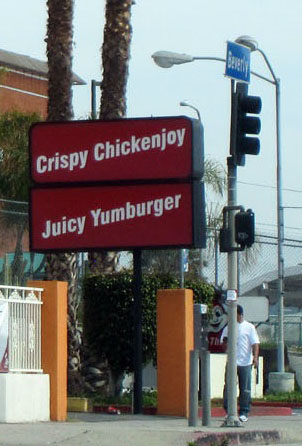
A couple of years ago I drove past this place in L.A. and promised to eat there and report back:
Jollibee is a fast food chain from the Philippines. It's an American fried chicken and burger joint, to be specific. I find it interesting that the American fast food concept gets exported to distant countries, and then the people from there export it right back.
I'd been wanting to try this for a while, but wasn't until I was passing by, ravenous after the Mount Baldy hike in August, that it became irresistible. I had always wanted to try both the joy of the Chickenjoy and the yum of the Yumburger, but as it turned out Chickenjoy was on sale if you went for the bucket, so Chickenjoy it was!
The restaurant was full, and most of the patrons and many of the employees were Filipino, so it must be one of those essential tastes of back home for them. It was crowded, so we got takeout.
Crispylicious! Juicylicious!
I forget what they call those things on the left but they are a variation on sweet potato fries.
The verdict? Not bad, reminds me of the texture of the newfangled KFC when they brought that out many years ago. The breading is flaky, the chicken was OK, the flavour was pretty basic, but we realized there is a spicier version which we forgot to ask.
ChickenJOY though? That's a tall order. Chickensatisfaction, definitely. I don't eat fast food much, but would I eat this again, if I needed a quick meal.
Friday, October 26, 2012
Saturday, October 20, 2012
On top of Mount Baldy
I am a lazy blogger- I went to Mt. Baldy way back in August and have been meaning to post these photos for a long time.
I had no idea what I was getting into when I suggested climbing Mt. Baldy. I'd heard about it, usually in the context of that's where L.A. residents drive to in the winter months to see snow or even go skiing. I knew there was a trail up there, and thought it sounded like a nice little outing. Ed was happy to do the research for the trip, so luckily I was kept in the dark about what this hike involved, or I probably would have chickened out.
Here's a pic from the drive up, heading for one of the tunnels that goes up the mountain:
Not only do you gain a lot of elevation by driving part way up the mountain, at the end of the road there is a chairlift you can take to "Mount Baldy Notch" and you can start from there. It's still a 6.4 mile hike to the summit with a 2,200 foot elevation gain, so it's not like all the hard work is done.
I found out on the way up that I am now afraid of chairlifts! I'd been looking forward to the trip, and I have skied before so I have done chairlifts, but this time I found being on the chairlift really scary! I wonder if maybe because this is summer and you can see all the sharp rocks down below. This is also an old and rickety chairlift, or so it seemed.
It's also pretty far off the ground at times... scenic though!
Some other folks on the way up:
So, since you are already at over 7,000 feet elevation when you start, the views are spectacular right from the start. This is looking southeast:
Looking south:
This hike follows a ridge called the "Devil's backbone". In places there are steep scree slopes on either side of you just a couple of feet from the path, but I didn't find this scary at all.
Ed put together this panorama of it- it's worth clicking to see it larger:
A few pics of the views and trees on the way up:
OK, this is me panting for air on a break. This is the first time I'd ever hiked at such a high altitude, and I really felt it. I was still coping pretty well here, but once we started heading for the summit I would have to stop and rest every 10 steps or so. I generally have pretty good endurance on hikes, so I knew this was more than me being a wimp, it was the altitude.
This is an interesting part of the trail, it goes right across the scree on one of the slopes:
Heading towards the summit. There's a piece missing as Ed put this together with several photos. Ed was way ahead of me for this part of the hike.
Approaching the backbone again on the way down. The spot this photo is taken from is actually the scariest part of the hike, the trail is very narrow here and although you can't tell from the photo, the drop off to the right is VERY steep and the footing very loose.
A couple of the stunted, twisted trees:
A view from the chairlift on the way down- as I had suspected, the trip down was way scarier, with the valley dropping off in front of us! Gorgeous view though.
So that was my hike at Mount Baldy. Probably first and last! It was pretty much at the extreme of what I was capable of, due to the elevation gain, and with it being at a high altitude. Still, if I can make peace with the chairlift, I would love to go up again someday, if even just to hike the devil's backbone portion of the trail.
I had no idea what I was getting into when I suggested climbing Mt. Baldy. I'd heard about it, usually in the context of that's where L.A. residents drive to in the winter months to see snow or even go skiing. I knew there was a trail up there, and thought it sounded like a nice little outing. Ed was happy to do the research for the trip, so luckily I was kept in the dark about what this hike involved, or I probably would have chickened out.
Here's a pic from the drive up, heading for one of the tunnels that goes up the mountain:
Not only do you gain a lot of elevation by driving part way up the mountain, at the end of the road there is a chairlift you can take to "Mount Baldy Notch" and you can start from there. It's still a 6.4 mile hike to the summit with a 2,200 foot elevation gain, so it's not like all the hard work is done.
I found out on the way up that I am now afraid of chairlifts! I'd been looking forward to the trip, and I have skied before so I have done chairlifts, but this time I found being on the chairlift really scary! I wonder if maybe because this is summer and you can see all the sharp rocks down below. This is also an old and rickety chairlift, or so it seemed.
It's also pretty far off the ground at times... scenic though!
Some other folks on the way up:
So, since you are already at over 7,000 feet elevation when you start, the views are spectacular right from the start. This is looking southeast:
Looking south:
This hike follows a ridge called the "Devil's backbone". In places there are steep scree slopes on either side of you just a couple of feet from the path, but I didn't find this scary at all.
Ed put together this panorama of it- it's worth clicking to see it larger:
A few pics of the views and trees on the way up:
OK, this is me panting for air on a break. This is the first time I'd ever hiked at such a high altitude, and I really felt it. I was still coping pretty well here, but once we started heading for the summit I would have to stop and rest every 10 steps or so. I generally have pretty good endurance on hikes, so I knew this was more than me being a wimp, it was the altitude.
This is an interesting part of the trail, it goes right across the scree on one of the slopes:
Heading towards the summit. There's a piece missing as Ed put this together with several photos. Ed was way ahead of me for this part of the hike.
I made it! Me in my floppy hat.
I was so exhausted at the summit, that I didn't even look much at the views while up there. That's not as pathetic as it sounds though, as you have spectacular views the whole way up, and because of the backbone ridge you hike, the views are close to 360 degrees the whole way anyway.
This is me enjoying some dried mangos in one of the wind shelters people have built up there over the years. There's a small population of resident chipmunks that survive on what hikers feed them.
Sure is beautiful...
Approaching the backbone again on the way down. The spot this photo is taken from is actually the scariest part of the hike, the trail is very narrow here and although you can't tell from the photo, the drop off to the right is VERY steep and the footing very loose.
A couple of the stunted, twisted trees:
A view from the chairlift on the way down- as I had suspected, the trip down was way scarier, with the valley dropping off in front of us! Gorgeous view though.
So that was my hike at Mount Baldy. Probably first and last! It was pretty much at the extreme of what I was capable of, due to the elevation gain, and with it being at a high altitude. Still, if I can make peace with the chairlift, I would love to go up again someday, if even just to hike the devil's backbone portion of the trail.
Sunday, September 16, 2012
Los Angeles Arboretum
I am way, way behind in my blogging. You'd think, by the lack of posts here, that I had locked myself in the apartment for the summer and drawn the blinds. In fact, I was out doing lots of fun stuff, and if I can motivate myself (I will), I will show you some pics from the summer. Things probably won't be in order though.
In early August I went to the Los Angeles Arboretum and Botanical gardens. We'd actually set out to go the Huntington gardens, but accidentally arrived there on the one day per month when admission to the (expensive) gardens is free. "Great", you'd think, except that due to popularity, admission was by ticket only, and we were ticketless. Luckily, the arboretum is just a few more miles down the road, and way cheaper!
I won't post a lot of photos as I know plant photos put a lot of people to sleep. But here are a few of the more interesting sights of the day.
I had thought this was labelled as some sort of wattle, but I am probably confused. It's very science-fictiony, and was in the Australia garden:
There was a prehistoric forest to walk through- these are from a bamboo grove in that forest:
My mom used to have this one as a houseplant, it was in one of the tropical greenhouses:
There were peacocks at large all over the place:
This cool cactus was in the Africa garden:
This one was the floss silk tree, I forget which garden it was in.
More bamboo, black this time:
Some of the bamboo had been cut, here's what the stumps left behind look like:
I forget what this tree was called, but the garden was chock-full of bottle-tree like water conserving trees like this:
This is a historical adobe building on the property:
The weather was perfect, but there was one cloud in the sky, this is it:
I loved the arboretum. I'll still try to go to the Huntington gardens though, but this unplanned trip to the arboretum instead wasn't a disappointment.
Monday, September 3, 2012
EARTHQUAKE!!!
OK, it wasn't a doozy or anything, but this was my first California earthquake, or that I felt, anyway. There have been a cluster of them lately.
This one was weak, only 3.2 (now upgraded to 3.3. I hear) on the Richter scale, but as the epicenter was only about 3 km from me, the shaking was strong enough to rattle stuff and wake me from sleep:
Epicenter was at N34.0682 W118.3915, which seems to be someone's backyard garage on Oakhurst Dr., just north of Wilshire. The time was 3:26 a.m. pacific time.
Fun! I enjoy non-deadly non-damaging seismic events.
This one was weak, only 3.2 (now upgraded to 3.3. I hear) on the Richter scale, but as the epicenter was only about 3 km from me, the shaking was strong enough to rattle stuff and wake me from sleep:
Epicenter was at N34.0682 W118.3915, which seems to be someone's backyard garage on Oakhurst Dr., just north of Wilshire. The time was 3:26 a.m. pacific time.
Fun! I enjoy non-deadly non-damaging seismic events.
Sunday, August 19, 2012
Meanwhile, back at Paramount ranch...
I've been very slow to post my photos this summer. These are from a July hike in the Santa Monica mountains, on parkland that used to belong to Paramount studios. It has the "western town" set which has been seen in several movies and on TV, and is still used for filming sometimes.
Here's the general store, with the saloon in the background:
The barbershop, with part of the hotel to the right:
Horseback riders can use this park too, here are two rounding the corner of the hotel for a very western photo op:
The house on the left is occupied by a real live tenant, probably a groundskeeper / security person:
Streetscape:
Sheriff's jail house:
Shed at the edge of town:
I think the brick building on the left was the bank:
Farmer's exchange:
A couple of photos from the hike. The trails aren't really long, but it was a hot day, so they were certainly long enough.
Here's the general store, with the saloon in the background:
The barbershop, with part of the hotel to the right:
Horseback riders can use this park too, here are two rounding the corner of the hotel for a very western photo op:
The house on the left is occupied by a real live tenant, probably a groundskeeper / security person:
Streetscape:
Sheriff's jail house:
Shed at the edge of town:
I think the brick building on the left was the bank:
Farmer's exchange:
A couple of photos from the hike. The trails aren't really long, but it was a hot day, so they were certainly long enough.
Subscribe to:
Posts (Atom)